Annapurna Region
AnnapurnaCircuit
Overview
About This Trek
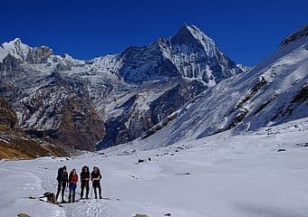
The Annapurna Circuit is one of the world's great long-distance treks, circumnavigating the entire Annapurna massif through an extraordinary range of landscapes and cultures. From the subtropical Marsyangdi valley to the arid, wind-carved terrain of upper Manang and the high crossing of Thorong La at 5,416 metres, this trek packs more diversity into a single route than almost any other walk on earth.
The eastern approach follows the Marsyangdi river northward, climbing through rice paddies, pine forests, and vertical gorges before reaching the Manang valley — a broad, dry plateau that feels more Tibetan than Nepali. Acclimatisation days in Manang (3,540m) allow side trips to ice lakes and viewpoints overlooking the Annapurna range. The crossing of Thorong La, the trek's highest point, is typically attempted before dawn to avoid afternoon winds.
After the pass, the descent leads to Muktinath, a sacred pilgrimage site for both Hindus and Buddhists, where natural gas flames burn eternally behind a Buddhist monastery. The western side of the circuit drops through the Kali Gandaki gorge — the deepest gorge on earth — past Jomsom and into the apple orchards of Marpha before returning to Pokhara. The full circuit offers a complete cross-section of Himalayan geography, culture, and challenge.
Trek Highlights
- Thorong La pass crossing at 5,416m
- Muktinath sacred temple visit
- Diverse climate zones in a single trek
- Manang valley acclimatisation and side hikes
- Kali Gandaki — deepest gorge on earth
- Traditional Manangi and Tibetan villages

Day by Day
SampleItinerary
Every itinerary is customised to your pace and fitness. This is a typical schedule — Deu adjusts based on conditions and your preferences.
Day 1
Pokhara to Chame
Drive along the Marsyangdi river valley to the district headquarters of Chame. Pine forests and the first views of Annapurna II.
Altitude: 2,670m
Day 2
Chame to Upper Pisang
Trek through apple orchards and deep forest. Cross to the northern trail for views of Annapurna II and Pisang Peak.
Altitude: 3,300m
Day 3
Upper Pisang to Manang
Traverse the dry, windswept Manang valley with views of Annapurna III, Gangapurna, and Tilicho Peak.
Altitude: 3,540m
Day 4
Acclimatisation day in Manang
Rest day with optional hike to Gangapurna Lake, Praken Gompa, or the Ice Lake at 4,600m.
Altitude: 3,540m
Day 5
Manang to Yak Kharka
Gradual ascent through dry terrain with dwarf junipers. Views open up to Chulu peaks and the Great Barrier.
Altitude: 4,018m
Day 6
Yak Kharka to Thorong Phedi
Short trek to the base of Thorong La. Afternoon rest before the early-morning pass crossing.
Altitude: 4,525m
Day 7
Thorong La to Muktinath
Alpine start (3-4 AM) for the pass crossing. Steep climb through scree and snow to 5,416m, then long descent to the sacred temple complex.
Altitude: 3,800m
Day 8
Muktinath to Jomsom
Descend through the Kali Gandaki gorge. Windy afternoon conditions are normal. Visit Kagbeni's medieval fortress town.
Altitude: 2,720m
Day 9
Jomsom to Tatopani
Continue south through the gorge, passing apple orchards in Marpha and dramatic cliff faces. Hot springs await at Tatopani.
Altitude: 1,190m
Day 10
Tatopani to Ghorepani
Steep climb from the gorge floor up to the ridge village of Ghorepani through rhododendron forest.
Altitude: 2,860m
Day 11
Poon Hill sunrise, trek to Nayapul
Dawn hike to Poon Hill for panoramic views, then descend through forests and villages to Nayapul. Drive to Pokhara.
Altitude: 1,070m
The Landscape
Terrain
The circuit crosses every major climate zone found in Nepal. The eastern approach is lush and green, with terraced farmland and dense broadleaf forest. Above Manang, the landscape turns arid and rocky, resembling the Tibetan plateau with its sparse vegetation and prayer flag-strewn passes. The Thorong La crossing involves steep scree and packed snow in some seasons. The western descent through the Kali Gandaki follows the deepest gorge on earth, flanked by Dhaulagiri (8,167m) and Annapurna I (8,091m).
The People
Culture
The circuit passes through multiple ethnic zones. Lower Manang is home to the Gurung and Manangi people, skilled traders who historically held special permits to conduct business across the Himalayas. Upper Manang and Mustang communities are ethnically Tibetan, with Buddhist monasteries, mani walls, and prayer wheels lining the trail. Muktinath temple, at the foot of Thorong La, is sacred to both Hindus (as a Vishnu temple) and Buddhists (as a site where Guru Rinpoche meditated). Marpha village in the Kali Gandaki is famous for its apple brandy and whitewashed stone architecture.
Before You Go
PracticalInformation
Permits Required
- Annapurna Conservation Area Permit (ACAP) — NPR 3,000 (~USD 23)
- TIMS Card — NPR 2,000 (~USD 15)
Guide Fees
- Guide — €40 per day
- Porter — €30 per day
Deu arranges all permits before your arrival. Permit costs are in addition to guide fees.
Packing Essentials
- Four-season sleeping bag (-15°C rating for Thorong La)
- Down jacket and warm layers for the pass
- Sturdy boots with good ankle support
- Trekking poles (essential for the pass descent)
- Altitude sickness medication (Diamox — consult doctor)
- Headlamp with spare batteries (pre-dawn start on pass day)
- Wind-proof outer layer (Kali Gandaki winds are fierce)
- Electrolyte supplements for hydration at altitude
When to Go
Best Season
October-November & March-April
October and November offer the clearest skies and most stable weather across Nepal, with excellent visibility and comfortable daytime temperatures. March to May is warmer with longer days and rhododendron blooms at lower altitudes, though afternoon clouds are more common. Deu can advise on the best timing for your specific trek and preferences.
Common Questions
FrequentlyAskedQuestions
How hard is the Thorong La pass crossing?
Thorong La at 5,416m is the trek's crux. The ascent from Thorong Phedi gains 900 metres over 4-5 hours on steep, loose terrain that may be snow-covered. The main challenges are altitude, cold (-15 to -25°C at dawn), and fatigue. With proper acclimatisation in Manang and an early start, most reasonably fit trekkers complete the crossing. Deu assesses conditions and each trekker's fitness before attempting the pass.
Can I do the Annapurna Circuit in reverse?
Yes, but it is much harder. Crossing Thorong La from west to east means a steeper, longer ascent of 1,600 metres in one day compared to 900 metres going east to west. Most trekkers and guides prefer the standard counter-clockwise direction for better acclimatisation and a more manageable pass day.
How long does the Annapurna Circuit take?
The classic full circuit takes 14-21 days depending on pace, acclimatisation needs, and side trips. The most common itinerary is 16-18 days. Starting from Chame (skipping the lower section by jeep) reduces it to 12-14 days without losing the best scenery. Deu customises the itinerary based on your fitness and available time.
Is the Annapurna Circuit suitable for beginners?
The circuit requires good fitness and stamina for sustained multi-day walking. It is not a beginner hike, but you do not need mountaineering experience. If you can comfortably walk 6-8 hours a day with a light daypack on hilly terrain, you have the baseline fitness. Altitude is the main variable — previous experience above 4,000m is helpful but not essential.
What is the Kali Gandaki gorge like?
The Kali Gandaki is the deepest gorge on earth, flanked by Dhaulagiri (8,167m) and Annapurna I (8,091m). Walking through it is like passing between two giant walls of rock and ice. The gorge funnels fierce afternoon winds from the south, so most trekking is done in the morning. The riverbed is dry and wide, scattered with ammonite fossils (shaligrams) sacred to Hindus.
Explore More